
Frisco Herd Management Area
Gentle mustangs, fierce badgers, gregarious goldfinches, and the silent, crumbling remnants of a dark and deadly human past.

The Frisco HMA covers about 95 square miles enveloping the San Francisco Mountains, just 15 miles northwest of Milford, Utah. The BLM’s 2015 population estimate placed this herd’s size at 146 horses; however, 113 mustangs were removed in July, 2016. Factoring in population growth, the number of horses remaining after this gather would have been between 40 and 50, but I had little difficulty finding about a dozen or so during an October 2016 visit. Oddly, the 2017 population estimate came in at 168 ... I'm not sure how that math works, but it's nice to know enough mustangs yet remain to make this trip worthwhile.
The mustangs seem to favor the foothills and rolling knolls east of Frisco Peak, the highest summit of the San Francisco Mountain Range. The ruins of Frisco and Newhouse, two Nineteenth Century mining towns, lie just outside the southern and southwestern borders of the defined herd area.


The historical marker beside UT-21 labels Frisco a “typical mining town,” providing a few statistics defining the “fabulous” but short-lived boom. Various historical summaries around the web paint a more colorful picture, calling to mind scenes from HBO’s Deadwood. But a visit to the Frisco Cemetery recasts these depictions in darker, bluer hues. The majority – by far – of the headstones remaining in this despairing plot commemorate the brief lives of infants and children. What a cruel, harsh, godforsaken place this must have been.


But don't let my mournful reflections deter you. This is a fascinating and beautiful area, close to the conveniences of civilization, yet far removed from its impositions and distractions.


Getting There
From Main Street, Milford, travel west on Center Street (which becomes UT-21) 8.3 miles to Frisco Peak Road. Watch for this dirt road on your right, immediately after the bridge spanning a seasonal gulch between mile markers 69 and 68. Follow 0.4 mile until the road forks, taking the right-hand route onto 3 Kilns Spring Road. This road is very smooth and easy to drive in the beginning, but grows more rugged as you venture further in. High clearance 4WD is recommended for traversing occasional ruts and gullies carved by seasonal runoff. Remain on this road for the next 6.0 miles, until the road forks again. Your chances of spotting mustangs will improve steadily through the second half of this leg.


Viewing Locations
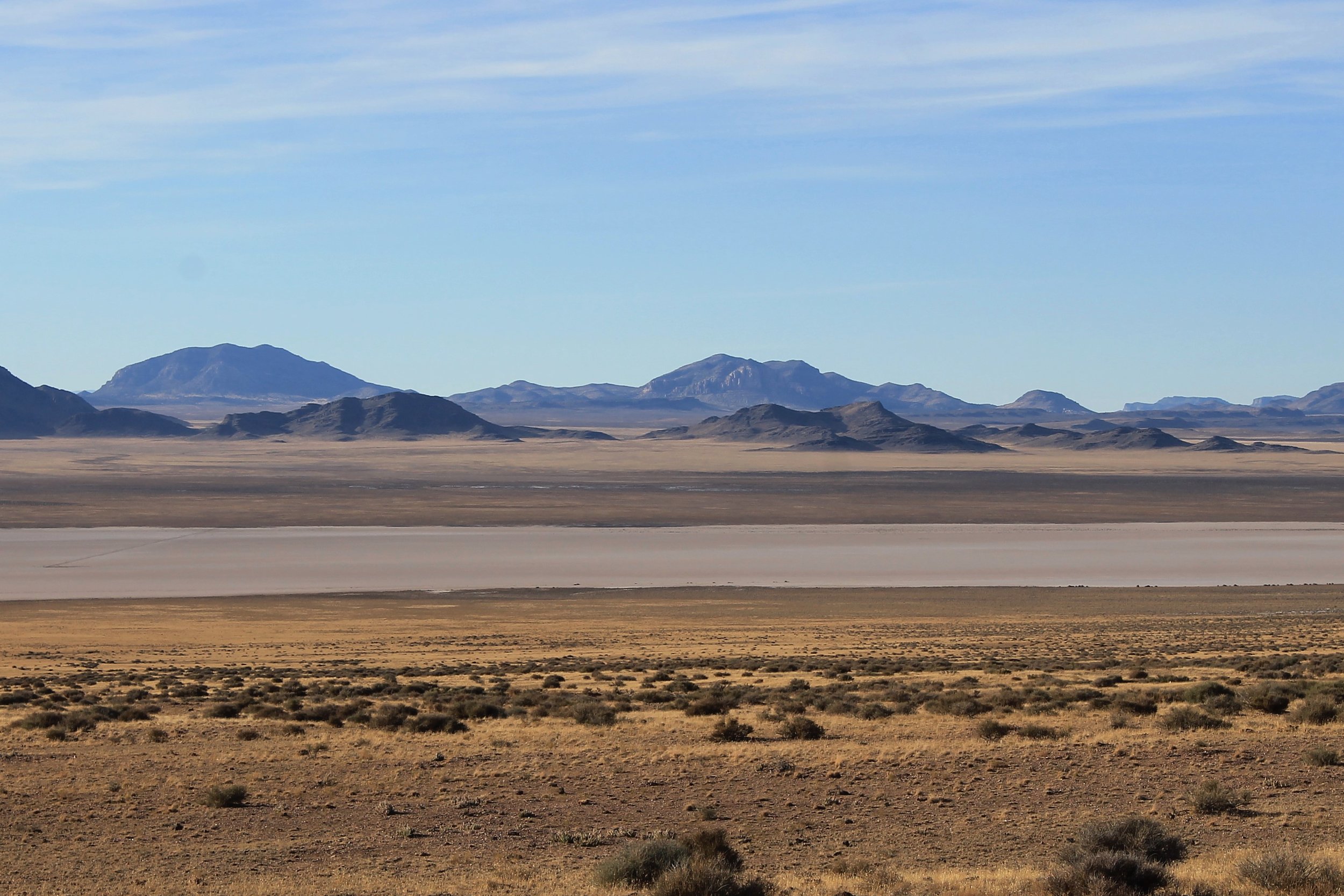
For a smoother ride with good mustang-spotting odds, keep right at the 2nd Fork (where the directions above end). Continue 3.3 miles until the road ends in a T-intersection. Turn right and drive eastward 4.0 miles to Iron Mine Pass Road. Turning right here will take you directly back to Milford. To continue your adventure, turn left, driving 10.1 miles northward through Iron Mine Pass to the western side of the San Franciscos for a stunning view across the Wah Wah Valley. Turn right when the road ends in a T-intersection with Crystal Peak Road, at the southern edge of the Sevier Lake hardpan. Travel east 11.3 miles to reach Route 257, turning right to return to Milford or left to continue toward Delta.
For a slightly more challenging drive, which includes a pass beside the kilns of 3 Kilns Spring, take the left leg at the 2nd Fork mentioned above. Venture 3.7 miles through the foothills, beginning northwesterly before turning directly north toward the first T-intersection mentioned in the previous paragraph. Turn left, continuing north toward 3 Kilns Spring (you can't miss it). Follow this trail as it meanders eastward, northward, and east again, ultimately rejoining the "smoother" route 5.5 miles later. Turn left to proceed through Iron Mine Pass, 6.7 miles to Crystal Peak Road. Turn right, driving 11.3 miles to Route 257.


Other Points of Interest
There are three locations of interest to ghost town enthusiasts. All are on private property, so please be respectful and appreciative of the fact that the owners have left most of these ruins open to public access.
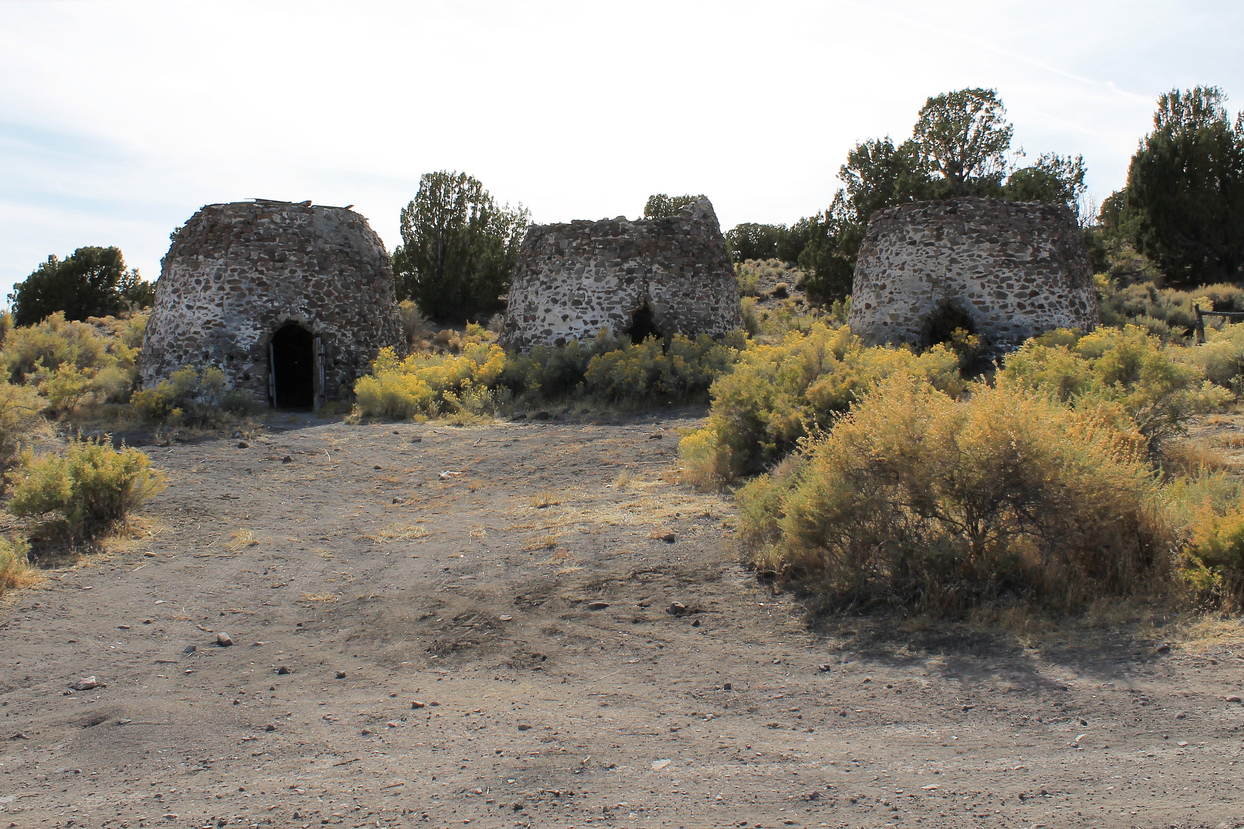
Frisco ruins, including five large smelting kilns: This is the first location you approach, 14.0 miles west of Milford (5.7 miles beyond the Frisco Peak Road turnoff). Follow the dirt road as it turns northward into the old camp.
Frisco Cemetery, with a view of the Horn Silver Mine structures: About ¾ of a mile further west, easily identified by the historic marker and picnic pavilion beside the highway. The road splits to either side of this pavilion, with the left-hand route leading to the burial grounds about half a mile in. Remnants of the old Horn Silver Mine are not accessible, but clearly visible from this location.
Newhouse: Five miles further west from the historical marker, then about 2.2 miles north.
Key GPS Coordinates
- Frisco Peak Rd from UT-21: 38° 26.348' N113° 9.202' W
3 Kilns Spring Rd from Frisco Peak Rd (first Y): 38° 26.620' N113° 9.371' W
Second Y along 3 Kilns Spring Rd: 38° 31.365' N113° 10.396' W
First T, end of 3 Kilns Spring Rd: 38° 33.875' N113° 11.074' W
Iron Mine Pass Rd from Smoother Route: 38° 34.319' N113° 6.989' W
Iron Mine Pass Rd from Rougher Route: 38° 36.977' N113° 8.566' W
Crystal Peak Rd from Iron Mine Pass Rd: 38° 41.777' N113° 10.302' W
Crystal Peak Rd from Iron Mine Pass Rd: 38° 43.008' N112° 58.133' W
Frisco Ghost Town: 38° 27.592' N113° 15.180' W
Frisco Cemetery from UT-21: 38° 27.166' N113° 15.564' W
Frisco Cemetery: 38° 27.046' N113° 16.115' W
Newhouse Ghost Town from UT-21: 38° 26.842' N113° 20.159' W
Newhouse Ghost Town: 38° 28.706' N113° 20.463' W
Nearest Herd Areas
Blawn Wash: 15 miles southwest
Four Mile: 25 miles southwest
King Top: 30 miles northwest
Sulphur: 40 miles west
Click here to visit the BLM's page for this HMA